(NEW YORK) — After two weeks of deadly storms ripping through states in the South, another severe storm is headed toward Texas, Louisiana and Florida.
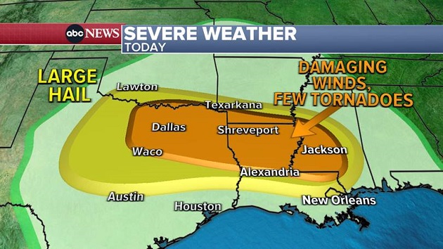
On Monday, a new storm will begin to move into the South with severe thunderstorms expected from Dallas to Shreveport, Louisiana, and into Jackson, Mississippi. There is a strong possibility for damaging winds, large hail and a few tornadoes as well.
Already in the last 24 hours, there has been pingpong ball-sized hail falling across Florida and western Texas.
On Tuesday, severe weather is expected in the Gulf Coast and the Southeast, from New Orleans to Charleston, South Carolina. Several tornadoes will be possible in Montgomery, Alabama, central Georgia and into South Carolina.
Another storm system from the West will begin to move into the same areas Wednesday, potentially bringing more damaging winds, a few tornadoes and large hail from Birmingham, Alabama, to Atlanta and into Asheville, North Carolina.
In the West, an atmospheric river is pounding Washington and Oregon with up to several feet of snow in the mountains, and there is the threat of flooding in lower elevations around the states as well as the coast. Gusty winds from this storm will stretch from Washington to Wyoming, where gusts could reach as high as 100 mph.
Snow totals in the Cascades in Washington and Oregon could reach several feet in the next 48 hours. In the Rockies, up to a foot of snow is possible from Idaho to northern Colorado.
Meanwhile, in the Southwest, particularly in parts of California, record-breaking heat is expected by the end of the week, with temperatures rising into the mid- to upper 90s. Triple digits are possible Thursday in areas such as Burbank, Sacramento and San Jose.
Copyright © 2022, ABC Audio. All rights reserved.
