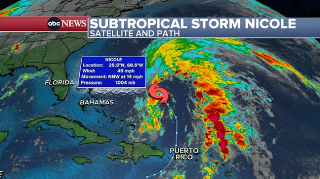
(NEW YORK) — A tropical storm and storm surge warnings are now in effect along the east coast of Florida as Subtropical Storm Nicole makes its way toward the state, according to the National Weather Service.
The NWS warned Monday that Nicole could be as strong as a hurricane when it approaches Florida’s east coast later this week.
The storm could impact election week in the Sunshine State, where Republican Gov. Ron DeSantis is running against Democratic rival Charlie Crist and Rep. Val Demings, D-Fla., is trying to unseat Sen. Marco Rubio, R-Fla.
DeSantis has declared a state of emergency for 34 counties.
“While this storm does not, at this time, appear that it will become much stronger, I urge all Floridians to be prepared,” he said in a statement. “We will continue to monitor the trajectory and strength of this storm as it moves towards Florida.”
Florida Power & Light is urging customers to prepare for power outages and has activated its emergency response plan ahead of Nicole’s potential impact on the state this week.
“[Hurricane] Ian saturated soil and weakened trees in many parts of the state, so Nicole could cause trees to topple over and other vegetation and debris to blow into overhead power lines and equipment, which may cause outages,” Eric Silagy, chairman and CEO of FPL, said in a statement.
Nicole formed in the southwestern Atlantic Ocean on Monday, becoming the 14th named storm of the 2022 Atlantic hurricane season, which ends this month. Nicole’s center will approach the northwestern Bahamas on Tuesday, move near or over those islands on Wednesday, then approach eastern Florida by Wednesday night, according to the National Weather Service.
Currently, Nicole wields maximum sustained winds of about 45 miles per hour, with higher gusts. Winds of 40 mph or greater extend outward up to 275 miles to the east of the storm’s center.
“Gradual strengthening is forecast during the next few days, and Nicole could be near or at hurricane intensity by Wednesday or Wednesday night while it is moving near the northwestern Bahamas,” the National Weather Service said in a public advisory issued Monday morning.
A tropical storm watch is now in effect for the northwestern Bahamas.
Tropical storm conditions are possible in the northwestern Bahamas by Tuesday night or early Wednesday. A storm surge could raise water levels by as much as 3 to 5 feet above normal tide levels along the coast in areas of onshore winds, according to the National Weather Service.
Nicole is expected to produce between 2 and 4 inches of rainfall across the northwestern Bahamas Tuesday through Thursday, with a maximum of 6 inches for localized rain. The storm is expected to bring “heavy rainfall” to parts of Florida and the southeastern United States by mid- to late week, the National Weather Service said.
Between 4 and 7 inches of rainfall is possible along the eastern coastline from Florida to the Carolinas. Tropical storm-force winds of 60 to 70 mph are also in the forecast, depending how much Nicole strengthens. The storm could lead to beach erosion, rough surf and rip currents.
Tropical weather systems have the potential to quickly grow into hurricanes, while subtropical ones do not. A subtropical storm typically generates more rain and heavy thunderstorms. If a subtropical storm intensifies enough to have hurricane-force winds, then it has become fully tropical. There is no such thing as a subtropical hurricane, according to the National Weather Service.
Copyright © 2022, ABC Audio. All rights reserved.
