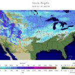
Across the Corn Belt, a variable snow cover remains in place. The greatest depths exist across the upper Midwest, where in some places snow has been on the ground since late November. Early Friday, snow showers associated with a fast-moving cold front are crossing the upper Mississippi Valley and spreading into the Great Lakes region. The snow showers and gusty winds are resulting in mostly minor travel disruptions.
On the Plains, high winds are raking parts of the Dakotas in the wake of a cold front’s passage. On January 26, wind gusts topped 60 mph in North Dakota locations such as Williston, Minot, and Garrison. Early Friday breezy conditions cover much of the remainder of the Plains, while rain and snow showers are developing in parts of Montana. The precipitation in Montana is associated with a new disturbance, closely trailing the recently departed cold front.