Articles by J.P. Skelly

Weather
Severe Thunderstorm Warning issued August 28 at 12:07AM MDT until August 28 at 12:45AM MDT by NWS
The National Weather Service in Sioux Falls has issued a * Severe Thunderstorm Warning for… Southeastern Davison County in southeastern South Dakota… Southwestern McCook County in southeastern South Dakota… Southern Hanson County in southeastern South [Read More…]
Weather
Severe Thunderstorm Warning issued August 27 at 11:56PM MDT until August 28 at 12:15AM MDT by NWS
…A SEVERE THUNDERSTORM WARNING REMAINS IN EFFECT UNTIL 115 AM CDT FOR SOUTHEASTERN DAVISON…SOUTHERN HANSON AND NORTHWESTERN HUTCHINSON COUNTIES… At 1255 AM CDT, a severe thunderstorm was located over Dimock, or near Parkston, moving east [Read More…]
Weather
Severe Weather Statement issued August 27 at 11:56PM MDT until August 28 at 12:15AM MDT by NWS
…A SEVERE THUNDERSTORM WARNING REMAINS IN EFFECT UNTIL 115 AM CDT FOR SOUTHEASTERN DAVISON…SOUTHERN HANSON AND NORTHWESTERN HUTCHINSON COUNTIES… At 1255 AM CDT, a severe thunderstorm was located over Dimock, or near Parkston, moving east [Read More…]
Weather
Severe Thunderstorm Warning issued August 27 at 11:42PM MDT until August 28 at 12:15AM MDT by NWS
The National Weather Service in Sioux Falls has issued a * Severe Thunderstorm Warning for… Southeastern Davison County in southeastern South Dakota… Northeastern Douglas County in south central South Dakota… Southern Hanson County in southeastern [Read More…]
Weather
Weather
Severe Thunderstorm Watch issued August 27 at 7:55PM MDT until August 27 at 10:00PM MDT by NWS
SEVERE THUNDERSTORM WATCH 355 REMAINS VALID UNTIL 11 PM CDT THIS EVENING FOR THE FOLLOWING AREAS IN SOUTH DAKOTA THIS WATCH INCLUDES 11 COUNTIES IN CENTRAL SOUTH DAKOTA JERAULD IN EAST CENTRAL SOUTH DAKOTA
Weather
Severe Thunderstorm Watch issued August 27 at 5:39PM MDT until August 27 at 10:00PM MDT by NWS
SEVERE THUNDERSTORM WATCH 355 IS IN EFFECT UNTIL 1100 PM CDT FOR THE FOLLOWING LOCATIONS SD . SOUTH DAKOTA COUNTIES INCLUDED ARE AURORA BEADLE BON HOMME BRULE BUFFALO CHARLES MIX
Weather
Severe Thunderstorm Watch issued August 27 at 5:39PM MDT until August 27 at 10:00PM MDT by NWS
SEVERE THUNDERSTORM WATCH 355 IS IN EFFECT UNTIL 1100 PM CDT FOR THE FOLLOWING LOCATIONS SD . SOUTH DAKOTA COUNTIES INCLUDED ARE AURORA BEADLE BON HOMME BRULE BUFFALO CHARLES MIX
Weather
Weather
Weather
Severe Thunderstorm Watch issued August 04 at 11:56PM MDT until August 05 at 6:00AM MDT by NWS
SEVERE THUNDERSTORM WATCH 327 IS IN EFFECT UNTIL 700 AM CDT FOR THE FOLLOWING LOCATIONS SD . SOUTH DAKOTA COUNTIES INCLUDED ARE BON HOMME CLAY DAVISON HANSON HUTCHINSON LAKE
Weather
Severe Weather Statement issued August 05 at 12:56AM MDT until August 05 at 6:00AM MDT by NWS
…THE SEVERE THUNDERSTORM WARNING FOR SOUTHEASTERN DAVISON…CENTRAL MCCOOK AND SOUTHERN HANSON COUNTIES WILL EXPIRE AT 200 AM CDT… The storms which prompted the warning have moved out of the area. Therefore, the warning will be [Read More…]
Weather
Severe Thunderstorm Warning issued August 05 at 12:45AM MDT until August 05 at 1:00AM MDT by NWS
…A SEVERE THUNDERSTORM WARNING REMAINS IN EFFECT UNTIL 200 AM CDT FOR SOUTHEASTERN DAVISON…CENTRAL MCCOOK AND SOUTHERN HANSON COUNTIES… At 144 AM CDT, severe thunderstorms were located along a line extending from near Colton to [Read More…]
Weather
Severe Weather Statement issued August 05 at 12:45AM MDT until August 05 at 6:00AM MDT by NWS
…A SEVERE THUNDERSTORM WARNING REMAINS IN EFFECT UNTIL 200 AM CDT FOR SOUTHEASTERN DAVISON…CENTRAL MCCOOK AND SOUTHERN HANSON COUNTIES… At 144 AM CDT, severe thunderstorms were located along a line extending from near Colton to [Read More…]
Weather
Severe Thunderstorm Warning issued August 05 at 12:08AM MDT until August 05 at 1:00AM MDT by NWS
The National Weather Service in Sioux Falls has issued a * Severe Thunderstorm Warning for… Southeastern Davison County in southeastern South Dakota… Southwestern Lake County in east central South Dakota… Southeastern Sanborn County in east [Read More…]
Weather
Severe Thunderstorm Watch issued August 04 at 11:56PM MDT until August 05 at 6:00AM MDT by NWS
SEVERE THUNDERSTORM WATCH 327 IS IN EFFECT UNTIL 700 AM CDT FOR THE FOLLOWING LOCATIONS SD . SOUTH DAKOTA COUNTIES INCLUDED ARE BON HOMME CLAY DAVISON HANSON HUTCHINSON LAKE
Weather
Severe Thunderstorm Warning issued August 04 at 11:34PM MDT until August 05 at 12:15AM MDT by NWS
The National Weather Service in Sioux Falls has issued a * Severe Thunderstorm Warning for… Davison County in southeastern South Dakota… Southwestern Sanborn County in east central South Dakota… Northeastern Aurora County in south central [Read More…]
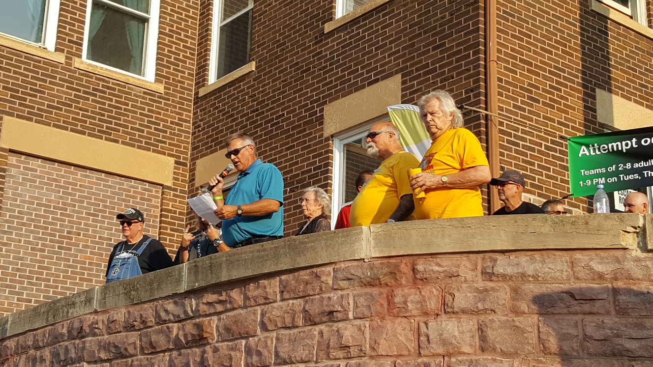
News
Palace City Pre-Sturgis Party a hit
Mayor Bob Everson spent a busy Thursday evening welcoming special guests and watching daredevil Cole Freeman’s record-setting jump during Mitchell’s first Palace City Pre-Sturgis Party that packed the Corn Palace area. He read a special [Read More…]
Weather
Weather
Special Weather Statement issued July 30 at 4:31PM MDT by NWS
…Funnel clouds possible through 8 PM CDT… Spotty showers and thunderstorms continue to track across the region this evening. As they develop, these storm may produce funnel clouds. These funnel clouds are expected to be [Read More…]
You must be logged in to post a comment.