Makenzie Huber, South Dakota Searchlight
Nine months after historic flooding in McCook Lake wreaked havoc on homes, roads, trees and infrastructure, government officials are widening their focus from recovery efforts to prevention.
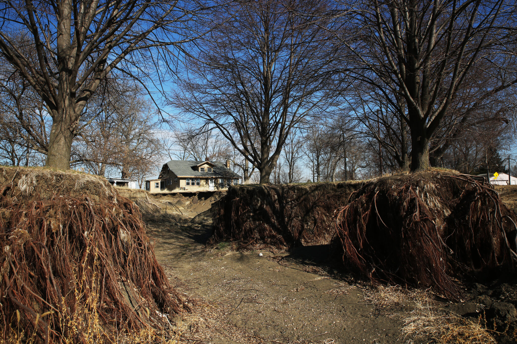
McCook Lake is a community of lakefront homes within North Sioux City in the southeastern corner of South Dakota, near the confluence of the Big Sioux and Missouri rivers.
Raging floodwaters that hit McCook Lake in June cost the city an estimated total of $15 million in infrastructure repair, according to North Sioux City and Union County officials. Homeowners suffered millions in additional damage and received some assistance from federal disaster relief programs, although not enough in some cases to replace their losses. Some also lacked flood insurance.
Local governments consider short-term, long-term mitigation plans
North Sioux City Administrator Jeff Dooley said the city is considering building greenways, culverts and storm sewer pipes along affected roads — capitalizing on some of the channels carved by the flood — to better direct future floodwaters into McCook Lake.
“Mother Nature has already plowed through there,” Dooley said. The city is also exploring how to better convey floodwaters from McCook Lake to the Missouri River “where it doesn’t harm anyone else.”

Dooley said a proposal will be presented to the public in late April for input from area residents and city commissioners. He plans to “hit these concepts hard” before applying for a Federal Emergency Management Agency hazard mitigation grant program by the end of May.
“A lot of damage has been done, and we’re doing our best to get out ahead of things,” Dooley said. “Any solution we come up with has to protect everybody.”
Dooley does not have a cost estimate prepared for the plan yet.

In the long term, Dooley and other area officials are requesting the U.S. Army Corps of Engineers to help reevaluate the current flood plan and develop new mitigation plans. The current plan, which uses levees to redirect floodwaters over Interstate 29 and into McCook Lake before they reach the rest of North Sioux City and nearby Dakota Dunes, was developed in 1976. Union County, North Sioux City and Sioux City wrote a letter to the Corps saying they will sponsor improvement projects recommended by the Corps.
While Dooley said the Corps of Engineers likely recognizes a nearly 50-year-old mitigation plan is outdated, he warned it’ll probably take 10 to 15 years for a study’s conclusions to come to reality. That’s because the project will have a large study scope and a long construction timeline, he said.
Residents continue with recovery, lawmaker seeks to provide future relief
More than 100 homes were damaged in the McCook Lake flood, and 20 homes were demolished by North Sioux City in December. That’s left pockets of empty lots around the north side of the lake.
Morgan Speichinger lives on North Shore Drive, an outlet off the lake’s main road. Before the flood, her family couldn’t see the lake because of the houses lining its shore. Then the raging floodwaters carved a channel toward the river in her family’s backyard and through her neighbors’ houses.
“We didn’t have a lake view. Now, unfortunately, we do,” she said.

Speichinger and her husband rented a skid-steer loader at the end of March to move some of the 66 truckloads of dirt donated by RP Constructors and the Dakota County Fire District to fill holes in their property and in empty neighboring lots.
Other volunteers, such as workers with Mitchell Electric, helped move dirt with vans and trailers.
“I love the help and volunteers willing to step up and help other people, but it’s frustrating that we have to rely on our community to bring us back together,” Speichinger said. “You don’t see the city, county or state leadership out here, but they’re the ones who should be helping.”

Vermillion Republican Rep. Chris Kassin has visited McCook Lake several times, walking the lake and assessing damage done to his constituents’ homes. Kassin led a failed effort to establish a fund for the cleanup and restoration of McCook Lake this legislative session.
Kassin plans to explore legislation to “find a creative solution” to offer state financial support to future natural disaster victims. He plans to work with the state Department of Public Safety, Department of Agriculture and Natural Resources, and Department of Game, Fish and Parks to understand what options are available.
“It showed some gaps in the way we deal with disasters in the state and some of the lack of funding triggers or mechanisms that we might have to help people in need,” Kassin said during a legislative panel Thursday at the University of South Dakota.
Speichinger said she and her family plan to remain in their home because they can’t afford to move elsewhere. She said any mitigation plan North Sioux City presents should include an overhaul of the 1976 plan.
State analyzes prediction and modeling failures
Tim Cowman is the state geologist and director of the South Dakota Geological Survey. In a meeting with the East Dakota Water Development District in late 2024, he said the Big Sioux River flooding came faster and harder than predicted by the National Weather Service. The flooding was caused by three days of rain June 20-22 in southeast South Dakota, surpassing 17 inches in some locations.
Cowman said the water started flowing over I-29 a mile before the levee.
“The flood would have happened at McCook Lake whether or not that levee was there,” Cowman said.

Some residents including Speichinger say the levee over I-29 made the flooding at McCook Lake worse, that they were not properly informed of the plan to install it, and were not sufficiently warned about the potential effects. She, a group of other residents and their attorney have since served the state of South Dakota with a notice of a potential lawsuit over its role in constructing the levee, although no lawsuit has yet been filed.
Cowman said future mitigation measures should plan for flood events like this more often.
“These are 100 and 500 year floods, but they happen every five years now,” Cowman said.

Experts say factors in that change may include more severe precipitation due to climate change, the conversion of sponge-like prairies to farm fields, the installation of drain tile under fields to dump excess moisture into creeks and rivers, and urban sprawl that sends more runoff into waterways.
Cowman helps predict flooding impacts for the state with the South Dakota Flood Information System, which produces flood maps based on different scenarios, including peak flows and breached levees.
Cowman said predictions of the “magnitude” of flooding that struck McCook Lake should be more accurate in the future, because they’ll include data from the 2024 flood.
He and his team met with the National Weather Service Missouri Basin River Forecast Center in Kansas City twice to “work out kinks” and understand modeling and timing failures.
“From the state’s standpoint,” Cowman said, “we’re trying to make sure the river forecast center doesn’t get fooled again on a flood of this magnitude down there.”