Seth Tupper/South Dakota Searchlight
State and local authorities knew they were placing McCook Lake in the path of record high floodwaters but failed to adequately warn residents of the danger, according to some people who live in the flood-ravaged community.
Authorities rejected the criticism and said they executed a long-established flood mitigation plan that was simply overwhelmed by record amounts of water. They also defended their communications, saying they gave multiple warnings to residents before the floodwaters arrived.
Both sides now face a long cleanup and questions about the future. Dirk Lohry, president of the McCook Lake Association, said the area needs a new flood mitigation plan.
“McCook Lake was sacrificed for the benefit of North Sioux City and Dakota Dunes,” Lohry said. “We don’t really think that’s fair.”
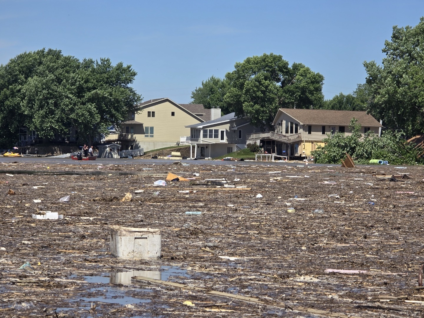
The crisis began last week when three days of historically heavy rain fell on areas as far as 140 miles north of McCook Lake. A pulse of high water flowed south down the Big Sioux River toward its confluence with the Missouri River. Before the Big Sioux reaches that spot in western Sioux City, Iowa, it flows by McCook Lake, North Sioux City and Dakota Dunes in the southeastern corner of South Dakota.
Long-established plan activated
North Sioux City has had a flood mitigation plan in place for decades, which includes building a temporary levee across Interstate 29 at Exit 4, less than 1,000 feet east of some of the 230 homes that line McCook Lake.
After North Sioux City officials activated the plan Saturday, state and local contractor crews helped build the levee. It ties in with permanent levees that protect North Sioux City and Dakota Dunes, which each have several thousand residents.
The levees are intended to divert floodwaters toward McCook Lake. Overflow from the lake goes south to the Missouri River, because the lake was formerly part of the river. It’s an oxbow — a horseshoe-shaped bend that was cut off long ago when the river changed course.
The plan has been implemented before, but never with so much water coming down the Big Sioux River. A gauge at Sioux City showed the river crested early Monday morning at about 45 feet, more than 7 feet higher than the previous record in 2014.
“The results of that are absolutely devastating,” Lohry said Monday.
Gov. Kristi Noem said during a Tuesday press conference in Yankton that at least “a couple dozen homes” were destroyed at McCook Lake.
“We have whole homes that have fallen into the lake,” Noem said. “We’ve got hundred-foot drop-offs from washouts, we’ve got live power lines laying across the roads, we’ve got boats stuck in trees, we’ve got trees that are half-falling over.”
Rescuers worked through Sunday night helping people escape. Authorities said Monday morning they had swept the community twice and found nobody trapped.
Adequacy of communications debated
Before the flood arrived, Noem led a press conference Sunday afternoon in North Sioux City with federal, state and local officials to talk about their mitigation and response plans.
They said McCook Lake could be affected, but nobody at the press conference issued an urgent verbal warning about the safety of lake residents. Dakota Dunes issued a voluntary evacuation order, but no such order was issued at that time for McCook Lake.
Noem fielded a question Sunday afternoon about how McCook Lake residents should prepare.
“What I would say to them is that, yes, they should be protecting their personal property on McCook Lake,” she said at the time, “because we do anticipate that they will take in water. That’s what we’re preparing for. If we don’t, then that’s wonderful that they don’t have an impact, but they could see water flowing into McCook Lake.”
Noem was working with rapidly changing forecast data for the Big Sioux River that was outdated by the time she announced it. She said during the press conference that the Big Sioux at Sioux City was projected to crest by 1 p.m. Monday at 42.2 feet. The actual crest was earlier and higher, at 10:30 p.m. Sunday and again at 3:30 a.m. Monday when the river reached 44.98 feet.
Jason Westcott, Union County’s emergency management director, said Tuesday in an interview with South Dakota Searchlight that he issued warnings throughout the weekend about potential flooding, both to social media and local media outlets.
“The belief was that the mitigation was going to work effectively,” he said.
When the situation grew unexpectedly dire Sunday evening due to the river rising higher and faster than anticipated, Westcott said he sent warnings to cell phones at McCook Lake and dispatched emergency responders to go door-to-door.
His office also posted an all-caps, bolded message to Facebook at 8:35 Sunday night:
𝐄𝐕𝐀𝐂𝐔𝐀𝐓𝐈𝐎𝐍 𝐍𝐎𝐓𝐈𝐂𝐄 𝐍𝐎𝐑𝐓𝐇 𝐒𝐈𝐎𝐔𝐗 𝐂𝐈𝐓𝐘 / 𝐌𝐂𝐎𝐎𝐊 𝐋𝐀𝐊𝐄 𝐀𝐑𝐄𝐀
𝐑𝐄𝐒𝐈𝐃𝐄𝐍𝐓’𝐒 𝐎𝐍 𝐍𝐎𝐑𝐓𝐇 𝐒𝐇𝐎𝐑𝐄 𝐅𝐑𝐎𝐌 𝐄𝐗𝐈𝐓 𝟒 𝐓𝐎 𝐃𝐀𝐊𝐎𝐓𝐀 𝐕𝐀𝐋𝐋𝐄𝐘 𝐇𝐈𝐆𝐇 𝐒𝐂𝐇𝐎𝐎𝐋 – 𝐏𝐋𝐄𝐀𝐒𝐄 𝐄𝐕𝐀𝐂𝐔𝐀𝐓𝐄!
Northshore Drive, which leads to the high school, was the area of McCook Lake most affected by flooding. By the time of the Facebook post, the Big Sioux was within inches of its crest.
Tyler Wood drove away from his McCook Lake home in “grille high” water with almost no time to spare.
“If it would have been two to three minutes later,” he said, “we wouldn’t have been able to get out of the street.”
Wood said he did not receive an alert on his phone. He said the closest thing he received to an urgent warning was a neighbor encouraging him to move belongings out of his basement about two hours before the deluge arrived.
“Any communication would have been beneficial instead of less than two hours prior to knowing that our house would maybe be a loss,” Wood said. “I know it’s hard to deliver on that, but finding out from neighbors in this situation just isn’t the best way to find out.”
Planning for the future
Monday morning at another press conference in North Sioux City, Noem defended the use of the temporary levee.
“I know that because of the levee system that is the emergency plan that’s followed by North Sioux City — and it was planned and followed successfully — that the industrial park and all of North Sioux City was saved from traumatic damage,” Noem said. “But we did see some at McCook Lake, and we saw houses that were significantly impacted.”
Westcott made similar comments at the Monday press conference.
“What occurred yesterday was a result of a mitigation effort,” he said. “Mitigation is designed to lessen the effects of flooding in our area, and also lessen the effects on critical infrastructure. If we did not take the mitigation efforts that we took yesterday, much of North Sioux City would be under water.”
Some McCook Lake residents are now at odds with authorities about access to homes and belongings. Noem and Westcott said Tuesday that much of the McCook Lake area is not safe, and it currently lacks power, gas and sewer service. Extra police have been brought in to keep people out, and Westcott said local authorities will work individually with McCook Lake residents to view their destroyed home or access their partially destroyed home.
Lohry, the lake association president, gives authorities some grace for their handling of an unprecedented situation. He’s not sure anything could have lessened the destruction at McCook Lake, given the unique circumstances.
“There was so much water, it overwhelmed everything,” he said.
But not every future flood will be as severe as this one, and Lohry wants changes to the flood mitigation plan. He suggests a ditch or canal to divert floodwaters from the Big Sioux around McCook Lake to nearby Mud Lake, which is not lined by houses, so the water could overflow there and drain through the state’s Adams Homestead and Nature Preserve down to the Missouri River.
“It requires some thought, but considering the expense of what we’ve gone through right here, I think the plan needs to be revised,” Lohry said. “I think there’s a more economical and safer way to do it.”
South Dakota Searchlight’s Makenzie Huber contributed to this report.


Satellite imagery before and during the June 2024 Big Sioux River flooding, from the U.S. Geological Survey Landsat program. (Illustration by John Hult/South Dakota Searchlight)