Articles by J.P. Skelly

Weather
Special Weather Statement issued December 24 at 10:07AM MST by NWS
…Fog Continues Through the Afternoon… Areas of fog will persist through the afternoon. While visibilities in many areas fall below 3 miles, some locations, including those near Huron and Mitchell may see visibilities fall below [Read More…]
Weather
Flood Warning issued December 24 at 8:51AM MST until further notice by NWS
…The Flood Warning continues for the following rivers in South Dakota… James River At Huron James River Near Forestburg James River At Mitchell James River Near Scotland
Weather
Flood Warning issued December 23 at 8:23AM MST until further notice by NWS
…The Flood Warning continues for the following rivers in South Dakota… James River At Huron James River Near Forestburg James River At Mitchell James River Near Scotland
Weather
Flood Warning issued December 22 at 8:04AM MST until further notice by NWS
…The Flood Warning continues for the following rivers in South Dakota… James River At Huron James River Near Forestburg James River At Mitchell James River Near Scotland
Weather
Flood Warning issued December 21 at 9:02AM MST until further notice by NWS
…The Flood Warning continues for the following rivers in South Dakota… James River Near Scotland …The Flood Warning continues for the following rivers in South Dakota… James River At Huron
Weather
Flood Warning issued December 20 at 10:10AM MST until further notice by NWS
…The Flood Warning continues for the following rivers in South Dakota… James River At Huron James River Near Forestburg James River At Mitchell James River Near Scotland
Weather
Flood Warning issued December 19 at 7:44AM MST until further notice by NWS
…The Flood Warning continues for the following rivers in South Dakota… James River At Huron James River Near Forestburg James River At Mitchell James River Near Scotland
Weather
Flood Warning issued December 18 at 9:54AM MST until further notice by NWS
…The Flood Warning is cancelled for the following rivers in South Dakota… James River Above Yankton …The Flood Warning continues for the following rivers in Nebraska…South Dakota… Missouri River At Niobrara
Weather
Flood Warning issued December 17 at 8:28AM MST until further notice by NWS
…The Flood Warning continues for the following rivers in Nebraska…South Dakota… Missouri River At Niobrara James River At Huron James River Near Forestburg James River At Mitchell
Weather
Flood Warning issued December 16 at 9:45AM MST until further notice by NWS
…The Flood Warning is cancelled for the following rivers in South Dakota… Big Sioux River Near Brookings …The Flood Warning continues for the following rivers in Nebraska…South Dakota… Missouri River At Niobrara
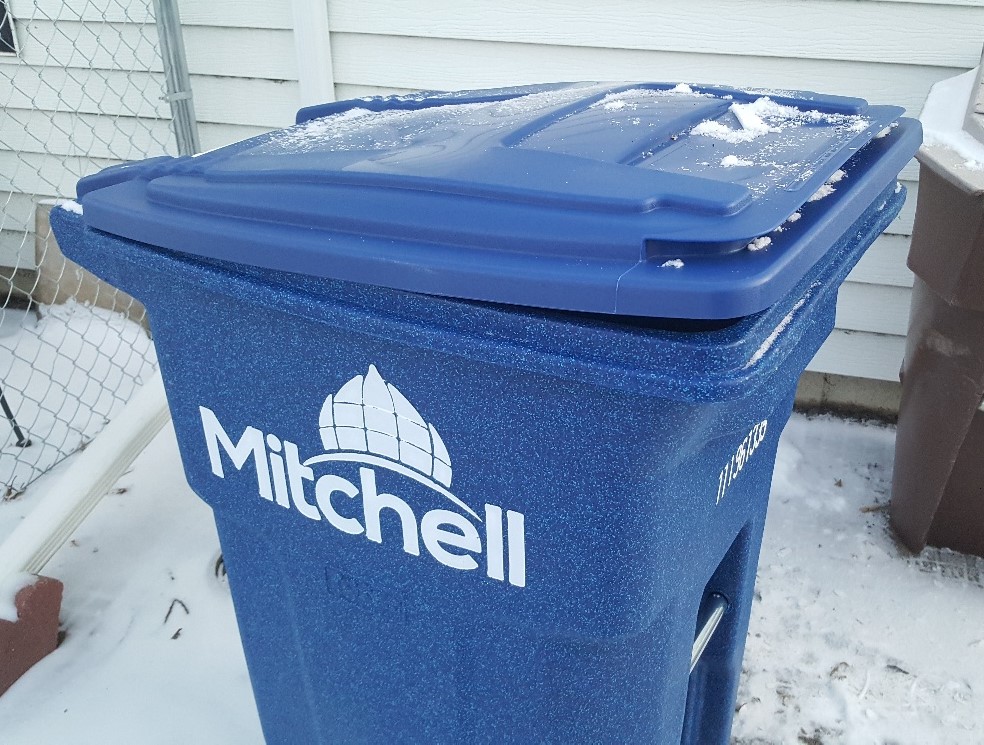
News
Many of Mitchell’s new blue recycling containers unable to fully close lids
The City of Mitchell is distributing new blue recycling containers it plans to use when it takes over residential recycling the week of January 6th. However there appears to be a problem as the lids [Read More…]
Weather
Flood Warning issued December 15 at 8:41AM MST until further notice by NWS
…The Flood Warning continues for the following rivers in Nebraska and South Dakota… Missouri River At Niobrara James River At Huron James River Near Forestburg James River At Mitchell
Weather
Flood Warning issued December 14 at 8:38AM MST until further notice by NWS
…The Flood Warning continues for the following rivers in Nebraska and South Dakota… Missouri River At Niobrara James River At Huron James River Near Forestburg James River At Mitchell
Weather
Flood Warning issued December 13 at 8:11AM MST until further notice by NWS
…The Flood Warning continues for the following rivers in Nebraska…South Dakota… Missouri River At Niobrara James River At Huron James River Near Forestburg James River At Mitchell
Weather
Dense Fog Advisory issued December 13 at 10:50AM MST until December 13 at 3:00PM MST by NWS
…DENSE FOG ADVISORY REMAINS IN EFFECT UNTIL 4 PM CST THIS AFTERNOON… * WHAT…Visibility one quarter to one half mile in dense fog. * WHERE…Portions of east central and southeast South Dakota, northwest Iowa and [Read More…]
Weather
Dense Fog Advisory issued December 13 at 9:43AM MST until December 13 at 3:00PM MST by NWS
…DENSE FOG ADVISORY REMAINS IN EFFECT UNTIL 4 PM CST THIS AFTERNOON… * WHAT…Visibility one quarter to one half mile in dense fog. * WHERE…Portions of east central and southeast South Dakota. * WHEN…Until 4 [Read More…]
Weather
Dense Fog Advisory issued December 13 at 8:07AM MST until December 13 at 3:00PM MST by NWS
…DENSE FOG ADVISORY IN EFFECT UNTIL 4 PM CST THIS AFTERNOON… * WHAT…Visibility less than one mile in dense fog. * WHERE…Portions of east central and southeast South Dakota. * WHEN…Until 4 PM CST this [Read More…]
Weather
Flood Warning issued December 13 at 8:11AM MST until further notice by NWS
…The Flood Warning continues for the following rivers in Nebraska…South Dakota… Missouri River At Niobrara James River At Huron James River Near Forestburg James River At Mitchell
Weather
Special Weather Statement issued December 13 at 5:27AM MST by NWS
…Locally Dense Fog Possible Friday Morning… Areas of fog will persist through at least mid-morning Friday. Locally dense fog will be possible at times, with visibility less than one half mile. Drivers should be prepared [Read More…]
Weather
Flood Warning issued December 12 at 8:58AM MST until further notice by NWS
…The Flood Warning continues for the following rivers in Nebraska and South Dakota… Missouri River At Niobrara James River At Huron James River Near Forestburg James River At Mitchell